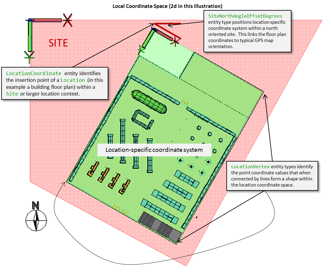
Subject Area Concepts The Enterprise Physical Locations View subject area represents a real-world, physical representation of the different places that are important to the retailer. Geographic Area HierarchyIt incorporates a geographic area decomposition set of entity types that retailers use to create multi-level views of their enterprise locations. Like other ARTS hierarchies, it supports the creation and maintenance of multiple named decompositions. The U.S. Census provides a detailed geolocation multi-level hierarchy that may be incorporated into the ARTS model as one of the retailer's GeographicSegmentHierarchy types. This approach is important for international retailers that want to incorporate different national geocoding schemes into their database to support analysis of business activity by customer type by standardized geographic area. ISO Standard Political SubdivisionsThe ARTS Data Model builds in ISO standards used to identify, name and designate countries and their major political subdivisions. In the United States, these codes identify the US at a country level and each of its states, territories and possessions at a political subdivision level. The ISO standard provides a single worldwide standard way to designate countries and their primary political subdivisions. Geophysical LocationFor mapping and geographic information system purposes, ARTS provides a set of entities to capture the longitude and latitude of each retailer Site and BusinessUnit (through the associative entity, BusinessUnitSite). Geophysical location related entities are intended to enable data sharing between ARTS databases and geographic information systems. In addition to business units within the retail enterprise, any address stored in the party contact Address entity may be cross referenced to a physical longitude and latitude (GeophysicalLocation) through the GeophysicalLocationAddress associative entity type. With the appropriate procedures and application services in place, retailers can use the ARTS Data Model to tie any business location within the enterprise or party to a geographic information system through the GeophysicalLocation entity. Postal Code ReferenceThe PostalCodeReference entity type incorporates the identifier used by national postal carriers to deliver mail. Each country has its own system for designating locations and postal codes. ARTS provides entity types that associate addresses (and through addresses, longitude and latitude) with postal codes. ARTS Location Reference ContextsARTS maintains two levels of location reference. The first is a site level location reference which places a Site at a GeophysicalLocation (longitude and latitude). This is the province of geographic information systems. The lowest level grain in this first level is the Site which in practice corresponds to a physical building or lot used by the retailer. The second level of location reference is inside the building or lot. In ARTS ODM V7.0/7.1 this intra-site location reference is represented by the Location entity type. The Location entity is sub-typed into SellingLocation and InventoryLocation entity types. A SellingLocation entity is typically used to identify and define a sales floor or showroom where customers can browse through the merchandise offered by a retailer. An InventoryLocation entity represents a named area inside a site where inventory is stored and tracked. In ARTS inventory tracking is tied to an InventoryLocation. The Location generalized entity type means that a SellingLocation and InventoryLocation represent two different aspects of the same place. Accordingly, retailers have the flexibility to identify, name and designate as many inventory locations as needed to monitor and control inventory movement both on the sales floor, in the backroom and through its warehouses and distribution centers. As discussed under Inventory Stewardship topic, inventory location is one of key dimensions used to monitor and control item unit counts. The Location entity in ARTS has a self-referencing foreign key that can be used to link locations as components of other locations. In theory this could be used to develop a hierarchy of inventory location levels. In practice this is not done in most implementations of the ARTS Data Model. In the future the ARTS Data Model will be extended to handle planograms and a more granular method for decomposing SellingLocation and InventoryLocation in a way that merges retail category management and space management into an integrated intra-site location reference scheme. ARTS Cross Reference Between GeoLocation and Party Contact InformationThe ARTS Data Model provides foreign key references to tie geophysical locations to party contact Address entities. This linkage is implemented through the GeophysicalLocationAddress entity and SiteContactMethod for intra-enterprise entities and the PartyContactMethod for external people and organizations. ARTS Version7.1 Location EnhancementsThe treatment of in-store locations is enhanced with the addition of support for a local coordinate system in ARTS ODM V7.1. The Site entity incorporates a SiteTypeCode (along with the SiteType reference table) to allow retailers to classify sites based on their business function as well as identify and name sites. Site also includes a SiteNorthAngleOffsetDegrees attribute used to position a site on a map that is oriented with the North at the top. This extension supplements the geographic coordinates already in the model. The RetailSiteTypeCode is a placeholder attribute that may be used to classify a site for real estate management purposes. It will be used as a link to a more complete set of entities used to support the real estate management functions of a retail enterprise in future data model versions. The Location entity is expanded to include structural properties useful for developing floor plans and maps. First a LocationTypeCode (along with a LocationType reference table) provides a way to categorize locations based on their function within a building (e.g. restrooms, public foyers, elevator, escalator, etc.). Two dependent entities provide coordinates of a location and may be used to enable intra-location navigation services using a local coordinate space. A local coordinate space defines a named set of X-Y-Z coordinates that are used to position shapes and features within a Location and Site. A Site may be positioned on a map using longitude and latitude which are part of the geodetic coordinate system used by global positioning systems (GPS). The local coordinate space establishes a Cartesian coordinate system that defines X-Y-Z coordinates within a site and within a location. The LocationCoordinate establishes placement of a location in a site and within another location scope. For example a building insertion point places it within a site. A floor insertion point places a vertical level within a building. An "auto parts insertion point" places the auto parts department within a floor. LocationCoordinate represents an anchor point for a location shape. A location shape is defined using a set of LocationVertex entity types. Each LocationVertex entity represents one X-Y-Z point. When the points are connected by lines they represent the geometry of the location. These two entities will be built on to establish a complete retail location mapping subject area used to support planogram functions and in-store mobile navigation services in future versions of the data model. Figure 74 - Local Coordinate Space Concepts
A new join entity explicitly associates a Location with a MerchandiseHierarchy group. This link, when combined with LocationCoordinate entity types, provides a basis for creating merchandise-aware intra-location maps. This foundation will be further developed to more comprehensively support floor plan mapping and navigation services in future data model versions. Version 7.1 supplements the location recursive relationship with a more flexible set of location hierarchy entities. These provide a mechanism to define the relationship between different locations that contain or are contained within other locations. The pattern for modeling the hierarchy follows the ARTS pattern used for merchandise hierarchy, organization hierarchy, etc. At this point the recursive Location relationship is being carried forward for backward compatibility. ARTS recommends that retailers use the new hierarchy structure which is more flexible and supports multiple kinds of location hierarchy.
|